|
|
 |
 |
100
specially selected 1:25 000 scale map extracts* covering
many of Britain's National Parks and ideal walking
areas, from the Scottish Highlands through to Cornwall.
Features include picnic areas, viewpoints and rights of
way information.
100 specially selected 1:50
000 scale map extracts* covering many general places of
interest.
20 new town and city centre
plans*, giving a total of 83.
6 new airport plans*,
including Stansted, Manchester and Glasgow, bringing the
total to 10.
5 new breathtaking fly-throughs
which include Lulworth Cove, Lundy Island and Glen Coe.
50 new photographs of places
of interest, taking the total to over 500.
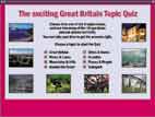
The Great Britain topic quiz
– answer selected questions from one of 8 new topics,
which include mountains and hills, places and people and
around the coast.
The Around Britain quiz – a
general knowledge quiz about all regions of Great
Britain.
A gazetteer containing a fully
searchable listing of over 42,000 place names.
Updated map skills tutorial
– aimed at increasing your understanding and
interpretation of maps.
Inclusive site licence – can
be used on a network at no extra cost.
Web link facility for
additional mapping.
* These map extracts cover
selected areas of Great Britain and are limited in their
coverage.
|
|
| ESS491 |
|
2 CD SET
Broaden your geographical knowledge of Great Britain.
Do you know where to find
Snails Hill and Sanda Island? Could you find your way to
Cape Wrath? The Ordnance Survey Interactive Atlas will
take you above and beyond your immediate locality to
broaden your geographical knowledge of Great Britain.
This two PC CD-ROM set covering the whole of Great
Britain brings you all the features of the latest vector
mapping data.
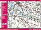
Disc A contains 1:250 000 scale mapping, interactive
symbols, 100 specially selected 1:50 000 scale map
extracts*, photos, fly-throughs, town plans*, a map
skills section and the Quiz Zone™.
Disc B contains 100 specially selected 1:25 000 scale
map extracts* that are ideal for walkers and cyclists
alike, covering areas such as the Lake District, the
Peak District, Snowdonia, Yorkshire Dales, Exmoor and
the New Forest, to name but a few. So as well as using
the maps to plan the routes yourself, you can also study
places of interest around the area, giving you the
ultimate opportunity to make detailed plans for trips,
days out or walks.
Data scales
The whole of Great Britain at
1:250 000 scale, showing features such as contour lines
and spot heights. Selected areas can be examined in fine
detail with 1:50 000 scale map extracts* on Disc A and
1:25 000 scale map extracts* on Disc B.
Town and city centre
plans
There are 20 additional town plans* – taking the total
to 83 – covering places such as Wolverhampton, Torquay,
Huddersfield, Southport and Penzance.
Advanced layers
Greater flexibility over previous editions to customise
the map content by using the expanded layer control
facility to switch off unwanted information.
Personalise your maps
Place your own map pins on areas of special interest.
Save favourite map views using the bookmark facility or
add text or web links to the pins.
Printing
All maps can be printed as standard print, with the
option of printing the 1:250 000 scale mapping as a
high-quality print. Maps can also be saved to file as
bitmap images.
|
|